Living in San Dorligo della Valle - Dolina: the Val Rosandra, the Karst and Trieste's industrial edge
The bilingual municipality of San Dorligo della Valle - Dolina has 5,671 residents, a hub hospital 8 min away and OMI values that, zone for zone, have risen 27.9% since 2021. December sun depends on the village: 8 h 27 min in Pesek on the Karst plateau, 3 h 33 min in Bottazzo at the bottom of the valley.
Published 10 November 2026
Driving times
- Udine
- 1 h 5 min
- Trieste
- 15 min
- Trieste Airport
- 41 min
- Klagenfurt
- 2 h 12 min
- The nearest sea
- 14 min
- The nearest slopes
- 1 h 51 min
- The motorway
- 24 min
- A station with trains
- 16 min
Health care
- 24h emergency room
- 8 min
- zone: 13 min
- Hub hospital
- 8 min
- zone: 22 min
Sunshine
- Direct sun on 21 December
- 6 h 34 min
- zone: 7 h 59 min
- Hours taken by the mountains
- 2 h 7 min
Prices (OMI)
- Standard homes
- €1,660/m²
- zone: €1,660/m²
- Detached houses
- €1,750/m²
- zone: €1,790/m²
- m² for €200,000
- 120 m²
- zone: 120 m²
- Rent
- €6.6/m² a month
Climate (1991–2020)
- January average
- 4.0 °C
- July highs
- 30.7 °C
- Rain per year
- 1,090 mm
- Frost days
- 52
Risks and broadband
- Seismic zone
- 3
- Buildings in flood area (P2)
- 5.8%
- Households with fibre
- 99.3%
- zone: 83.5%

Who lives here
- Residents
- 5,671
- Since 2001
- -5%
- Average age
- 50.3
- Empty homes (2011)
- 12%
Minutes of direct sun, day by day
direct sun with a flat horizon
One bilingual municipality, three landscapes
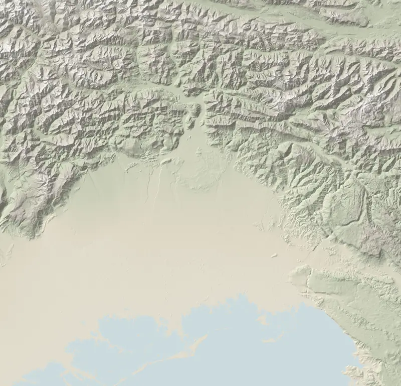
San Dorligo della Valle - Dolina rises from a few metres above the sea, beside Trieste's industrial zone, to 666 m on the Karst. Down on the flat are Domio, Mattonaia and Puglie di Domio; at the mouth of the valley, Bagnoli della Rosandra (Boljunec) and Dolina, home of the town hall; on the Karst slope and plateau, Sant'Antonio in Bosco (Boršt), Pesek, Grozzana (Gročana) and Draga. The council works in both Italian and Slovene, down to its resolutions, and several schools use Slovene as the language of instruction: the Italian Ministry of Education's register lists 8 of them.
- Residents: 5,671 now, 5,927 at the turn of the century; roughly one in three is over 65 (30%), average age 50.3.
- Housing: two residential buildings in three (68%) were built by 1970; 12% of homes had no registered occupant in 2011, holiday lets and second homes counted.
- The valley: the Val Rosandra regional nature reserve, set up in 1996, is run by the municipality.
- Industry: the municipality also hosts the Transalpine Pipeline's tank farm, 32 crude-oil tanks holding more than 2 million cubic metres, where the pipeline to Germany begins.
The other Karst municipalities are in our guide to Trieste and the Karst.
Prices up by over a quarter, a thin market
In OMI zone D1 (Domio, San Giuseppe della Chiusa, Mattonaia) standard homes went from €1,050/m²–€1,550/m² in 2021 to €1,500/m²–€1,800/m² in 2026; in the farmland zone R1, from Pesek and Grozzana to Bottazzo and Caresana, they stand at €1,550/m²–€1,800/m². In the old centres of San Dorligo and Bagnoli the OMI only prices economy-grade homes, €1,100/m²–€1,500/m². The regional statistics give a 2025 average of €1,538/m² and 49 sales, after two years of decline, and count San Dorligo, Sgonico and Monrupino among markets with few transactions.
- €200,000: roughly 120 m² in a flat, 115 m² in a detached house, at OMI prices.
- ILIA 2026: 0.92% on homes that are not the owner's registered residence, except the first one, which pays 0.70% if it is declared to the council (bilingual resolution no. 53 of 17 December 2025; how it works).
- Rents: €6.6/m² a month according to the OMI, 4.8% gross a year. Unlike Trieste, Muggia and Duino Aurisina, San Dorligo is neither on the CIPE list nor in the commissioner's acts after the 2009-2010 storms: on a regulated-rent (canone concordato) lease the 10% flat-rate tax is an uncertain option, and the cautious reading is 21% until the Agenzia delle Entrate rules on a formal query (the issue).
- First home: regional law classes the whole municipality as mountain land, so the grant rises to €15,500 (€20,000 for under-36s); it normally requires having lived in the region for five of the previous eight years (eligibility).
| San Dorligo della Valle | Muggia | Sgonico | Monrupino | Duino Aurisina | Trieste | |
|---|---|---|---|---|---|---|
| Standard homes (€/m²) | €1,660/m² | €1,975/m² | €1,775/m² | — | €2,040/m² | €2,100/m² |
| Prices over 5 years | 27.9% | 40.4% | 29.1% | — | 28.0% | 50.0% |
| Homes sold in 2025 | 49 | 197 | 16 | 8 | 113 | 3,585 |
| Sun on 21 December | 6 h 34 min | 7 h 28 min | 8 h 34 min | 8 h 32 min | 7 h 43 min | 7 h 34 min |
| 24h emergency room | 8 min | 16 min | 20 min | 15 min | 22 min | 9 min |
| From Trieste | 15 min | 18 min | 21 min | 16 min | 24 min | 2 min |
The valley steals the sun, the Karst gives it back
Where the Val Rosandra opens out, by the town hall, direct sun on 21 December lasts 6 h 34 min: the hillside takes 2 h 7 min and the first ray only appears at 09:35 (our method). With the engine behind our home identity card, on OpenStreetMap points:
- in the valley: Bottazzo 3 h 33 min, Bagnoli Superiore 4 h 9 min, Dolina village 5 h 10 min, Bagnoli della Rosandra 6 h 16 min;
- on the flat: Domio 7 h 35 min;
- on the Karst: Sant'Antonio in Bosco 8 h 9 min, Pesek 8 h 27 min.
Climate on the ARPA grid: 52 frosty mornings, 45 afternoons above 30 °C, 1,090 mm of rain. These are estimates for the town hall's cell, not measurements: frost, which pools in valley bottoms, is the least certain figure.
Who is house-hunting here
Over the year to the end of October 2026, the TriesteVillas group heard from 175 people wanting to buy in the nine municipalities of our Trieste and Karst area, from Muggia to Sagrado, the city of Trieste excluded. Where nationality is known, 42% are foreign: 20 Austrians, 13 Slovenians, 12 Germans. More than half asked about Duino Aurisina or Muggia. They measure who wrote to us rather than the market as a whole; for San Dorligo the numbers are too small to publish (who buys from outside).
Trieste round the corner, the border too
- Hospital: Cattinara, 8 min without traffic, is both the nearest A&E and the closest hub for treating heart attacks and strokes (hospitals).
- City and border: Trieste 15 min, Ljubljana 1 h 12 min, Udine 1 h 5 min; the nearest station is Trieste Centrale, 16 min.
- Sea: swimming at San Rocco in Muggia is 14 min away; for sand, Marina Julia, 46 min.
- Broadband: fibre to the home now covers 99.3% of households (fibre).
- Hazards: seismic zone 3; ISPRA's medium flood scenario includes 5.8% of buildings (floods and landslides).
Questions
What does a house in San Dorligo della Valle cost?
In January–June 2026 the OMI valued standard homes at €1,500/m²–€1,800/m² around Domio, €1,550/m²–€1,800/m² in the farmland zone that includes the Karst villages; villas €1,500/m²–€2,000/m².
How much winter sun does San Dorligo della Valle get?
It depends on the village: on 21 December from 3 h 33 min in Bottazzo, deep in the Val Rosandra, to 8 h 27 min in Pesek on the Karst; 6 h 34 min at the town hall.
Sources and method
Written with AIChecked against the sources before publication.
The figures on this page come from:
- ISTAT — Altimetria dei comuni dal modello digitale del terreno (31/12/2021) (data as of 2026-10-07) · CC BY 4.0
- Ministero dell'Istruzione e del Merito — anagrafe delle scuole statali e paritarie, a.s. 2026/27 (SCUANAGRAFESTAT20262720260901, SCUANAGRAFEPAR20262720260901): sedi effettive per comune e grado, sedi con lingua d'insegnamento slovena (data as of 2026-10-22) · IODL 2.0
- ISTAT SITUAS — comuni, caratteristiche del territorio, dimensione, aree di policy (data as of 2026-10-07) · CC BY 4.0
- ISTAT — popolazione residente (censimenti 2001, 2011, permanente), indicatori demografici 2024, stranieri residenti (data as of 2026-10-22) · CC BY 4.0
- ISTAT — Censimento della popolazione e delle abitazioni 2011: abitazioni occupate e non occupate, epoca di costruzione degli edifici (data as of 2026-10-22) · CC BY 4.0
- TAL – Oleodotto Transalpino: «San Dorligo della Valle Tank Farm» (serbatoi del greggio e prima stazione di pompaggio) (data as of 2026-11-10)
- Agenzia delle Entrate — Osservatorio del Mercato Immobiliare (OMI): quotazioni per zona e tipologia; valore per comune = mediana dei punti medi delle zone OMI, stato normale (data as of 2026-10-22) · riuso con citazione della fonte (Agenzia delle Entrate – OMI)
- Agenzia delle Entrate – OMI, Statistiche regionali 2026 Friuli-Venezia Giulia (dati 2025): provincia di Trieste, Tabelle 10 e 11 e testo sui comuni del ciglione carsico; copia nel repo in atlante/fonti/prezzi/sr/ (data as of 2026-11-10) · CC BY 4.0, citazione obbligatoria «Agenzia delle Entrate – OMI»
- Agenzia delle Entrate — OMI, Statistiche regionali Friuli Venezia Giulia 2025: compravendite (NTN) e intensità del mercato (IMI) per comune (data as of 2026-10-22) · riuso con citazione della fonte (Agenzia delle Entrate – OMI)
- Regione FVG — Portale ILIA (Imposta locale immobiliare autonoma, L.R. 17/2022): aliquote 2026 dalle delibere comunali (210 comuni dal Portale ILIA, 5 dal MEF) (data as of 2026-10-29) · atti ufficiali: le aliquote sono fatti ripubblicabili
- D.Lgs. 14 marzo 2011, n. 23, art. 3 cc. 1, 2, 6: cedolare secca sugli affitti abitativi (21 %; 10 % sui contratti a canone concordato nei comuni ad alta tensione abitativa; per il D.L. 47/2014, art. 9 c. 2-bis, anche nei comuni colpiti da calamità con stato d'emergenza deliberato fra il 28/05/2009 e il 27/05/2014) (data as of 2026-10-25) · legge: pubblico dominio (art. 5 L. 633/1941), testo da normattiva.it
- Regione FVG — contributi per l'acquisto della prima casa (DPReg 144/2016 artt. 7-8, testo coordinato 08/08/2025; L.R. 1/2016 abrogata dalla L.R. 6/2026, regole in vigore fino ai nuovi regolamenti) (data as of 2026-10-22) · atti ufficiali
- Ore di sole diretto calcolate da FriuliVillas sull'orizzonte del modello del terreno Copernicus GLO-30 (raggi fino a 60 km, curvatura e rifrazione) e sulla posizione del Sole (algoritmo NOAA), dalla sede municipale a 2 m dal suolo, cielo sereno. Produced using Copernicus WorldDEM-30 © DLR e.V. 2010-2014 and © Airbus Defence and Space GmbH 2014-2018 provided under COPERNICUS by the European Union and ESA; all rights reserved. Copernicus e l'ESA non sono responsabili di questo uso dei dati né lo approvano. (data as of 2026-10-22) · licenza Copernicus DEM GLO-30
- FriuliVillas — ore di sole diretto il 21 dicembre calcolate col motore della «carta d'identità della casa» (Copernicus GLO-30, algoritmo NOAA, cielo sereno) sui villaggi e le borgate OpenStreetMap di San Dorligo della Valle e Sgonico (atlante/dati/sole-frazioni-carso.csv); punti © OpenStreetMap contributors (data as of 2026-11-10)
- ARPA FVG – OSMER: normali climatiche 1991–2020 sulla griglia regionale a 500 m e sulle stazioni (temperature, pioggia, gelo, caldo, neve, vento) (data as of 2026-10-22) · ARPA FVG - OSMER e GRN, CC BY-SA 3.0 IT: i valori del clima ripubblicati qui restano sotto la stessa licenza
- Richieste di acquisto ricevute dal gruppo TriesteVillas (vista «compratori» del CRM, aggregato anonimo con soglie di riservatezza): persone distinte che hanno chiesto una casa in un comune dell'area «Trieste e Carso» del sito (Trieste escluso) fra il 01/11/2025 e il 31/10/2026; misurano le richieste arrivate al gruppo, non tutto il mercato (data as of 2026-11-10) · dati interni dell'agenzia, pubblicati solo come aggregato
- Tempi in auto senza traffico (OSRM su OpenStreetMap) dalla sede municipale ai pronto soccorso e agli ospedali hub; elenco delle strutture dalle aziende sanitarie ASUFC, ASUGI, ASFO e dalla L.R. 22/2019 (data as of 2026-10-22) · dati © OpenStreetMap contributors, ODbL; fatti dagli atti pubblici
- OSRM (router.project-osrm.org) su dati OpenStreetMap — tempi in auto senza traffico dalla sede municipale (data as of 2026-10-07) · dati © OpenStreetMap contributors, ODbL
- Tempi in auto senza traffico (OSRM su OpenStreetMap, estratto Geofabrik del 20/10/2026) dalla sede municipale alle spiagge, ai poli sciistici, a Pordenone e Gorizia, agli svincoli autostradali e alle stazioni con treni (orari Trenitalia/FUC verificati per un giorno feriale) (data as of 2026-10-22) · dati © OpenStreetMap contributors, ODbL
- AGCOM — Broadband Map, copertura delle reti fisse per comune (rilevazione al 05/10/2026); Infratel Italia — piano Banda ultra larga (data as of 2026-10-22) · CC BY 4.0; Infratel: riuso con citazione
- Dipartimento della Protezione civile — classificazione sismica dei comuni (aggiornata al 31/05/2025) (data as of 2026-10-22) · CC BY 4.0
- ISPRA IdroGEO — indicatori di rischio per comune (frane: mosaicatura PAI 2024; alluvioni: mosaicatura 2020) (data as of 2026-10-22) · CC BY 4.0
- Regione FVG — Riserva naturale regionale della Val Rosandra (L.R. 42/1996 art. 52; perimetro modificato col DPReg. 98 del 27/07/2022; gestione affidata al Comune di San Dorligo della Valle) (data as of 2026-11-10)
- Agenzia delle Entrate – OMI, zones B1, D1 and R1 of San Dorligo della Valle, first half of 2021 and 2026 (2026-11-10)
- Agenzia delle Entrate – OMI, Statistiche regionali 2026 Friuli-Venezia Giulia: province of Trieste, Tables 10 and 11 (2026-11-10)
- Portale ILIA – Regione FVG: Municipality of San Dorligo della Valle - Dolina, resolution no. 53 of 17/12/2025, 2026 rates (2026-11-10)
- Regione FVG — Val Rosandra regional nature reserve (2026-11-10)
- TAL – Transalpine Pipeline: San Dorligo della Valle Tank Farm (2026-11-10)
- Decree-Law 47/2014, art. 9(2-bis): 10 % flat tax on regulated leases in municipalities with a 2009-2014 state of emergency (2026-11-10)