FriuliVillas
AI-animated video

FriuliVillas · Area

Hills & Plain: 138 municipalities from Pordenone to the Collio

The most populated part of the region: its cities, the Collio, the moraine hills and the plain down to the lagoon.

municipalities
138
for sale
3
from Trieste
1 h 12
from Udine
35 min
from Vienna
5 h 32
from Munich
5 h 07

Driving minutes, without traffic or border waits, to each municipality's town hall (for our homes, their own village when it was measured separately); for an area it is the median of its municipalities, excluding the one you start from. Measured with OSRM on 7 October 2026.

This is the largest of the four areas: 138 of the region's 215 municipalities, about 3,842 km² or almost half of Friuli Venezia Giulia, and 818,900 residents, more than two in every three people in the region. It includes the three former provincial capitals other than Trieste: Udine with 98,279 inhabitants, Pordenone with 52,314 and Gorizia with 33,620.

The name says what is inside. The regional landscape plan divides this territory into seven zones: the western foothills, the moraine amphitheatre, the eastern valleys and the Collio, the upper and lower Pordenone plain, and the upper and lower Friulian and Isonzo plain. When our catalogue grows, the area will split into Hills (47 municipalities) and Plain (91), using a rule that is already written.

From Udine, driving without traffic, the median is 35 minutes and the farthest municipality, Polcenigo, is 79 minutes away. From Trieste the median is 1 h 12 min, from Trieste Airport 48 minutes, from Venice airport 1 h 20 min. From Munich the nearest municipality is Osoppo, at about 4 h 30 min.

Inside the area

The Collio and Gorizia

Cormons, Capriva del Friuli, Dolegna del Collio, Mossa and San Floriano del Collio, together with Gorizia, form the heart of the Italian Collio; the Collio Goriziano DOC wine zone also takes in parts of Farra d'Isonzo and San Lorenzo Isontino. Gorizia is the municipality in this area closest to Ljubljana, about 78 minutes by car.

Cividale and the eastern hills

Part of the historic centre of Cividale del Friuli, the Lombard-era quarter, has been part of the UNESCO site ‘Longobards in Italy’ since 2011. Cividale is about 25 minutes from Udine; around it, Prepotto, Corno di Rosazzo, Torreano, Faedis, Attimis, Nimis and Tarcento trace the eastern hills as far as the River Torre.

The moraine hills and San Daniele

North-west of Udine, the moraine amphitheatre zone takes in fifteen municipalities: San Daniele del Friuli, Fagagna, Majano, Buja, Ragogna, Osoppo, Tricesimo, Moruzzo, Pagnacco and others. San Daniele is about 35 minutes from Udine.

The Pordenone foothills

Aviano, Budoia, Polcenigo, Caneva and Maniago lie at the foot of the Pordenone mountains. Regional mountain law counts them, wholly or partly, as mountain municipalities, but ISTAT classifies them as hills, so they are listed here rather than under Mountains.

The plain and the lowlands

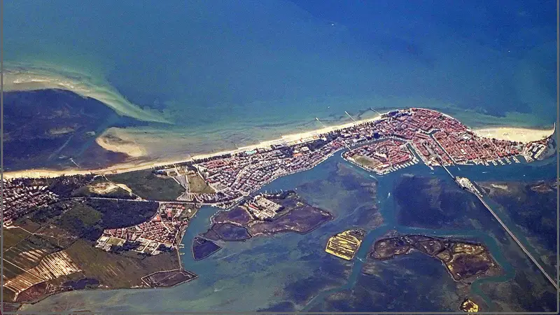
Ninety-one lowland municipalities, from the upper plain around Udine and Pordenone down to the lowlands that border the lagoon: Codroipo, Sacile, Cervignano del Friuli, Ronchi dei Legionari. Palmanova, the star-shaped fortress town built by Venice in 1593, has been part of the UNESCO site of Venetian defence works since 2017.

How far, measured

Frommediannearestfarthest
Trieste1 h 12Ronchi dei Legionari 36 minMontereale Valcellina 1 h 53
Udine35 minPasian di Prato 9 minPolcenigo 1 h 19
Trieste Airport48 minRonchi dei Legionari 6 minMontereale Valcellina 1 h 29
Venice Airport1 h 20Pravisdomini 46 minSan Pietro al Natisone 1 h 47
Ljubljana1 h 59Gorizia 1 h 18Montereale Valcellina 2 h 41
Klagenfurt2 h 06Osoppo 1 h 29Caneva 2 h 44
Vienna5 h 32Osoppo 5 h 00Caneva 6 h 14
Munich5 h 07Osoppo 4 h 30Caneva 5 h 45
Salzburg3 h 48Osoppo 3 h 11Caneva 4 h 26

Driving minutes, without traffic or border waits, to each municipality's town hall (for our homes, their own village when it was measured separately); for an area it is the median of its municipalities, excluding the one you start from. Measured with OSRM on 7 October 2026.

How the boundary is drawn

This area is what remains once the other three are drawn: a municipality belongs here if ISTAT does not classify it as inland mountain, if the landscape plan does not place it in the Karst, and if it is neither coastal nor mostly within the lagoon zone. The borderline cases: Gorizia, which the plan splits between upper plain (59%) and Collio (41%); the Natisone valleys above Cividale, which ISTAT counts as mountain (except San Pietro al Natisone, hill) and which therefore go to Mountains; the Collio, which ISTAT classifies mostly as plain (San Floriano is hill) but the plan places among the hills; and Ronchi dei Legionari, the only municipality here whose centre is less than 5 km from the sea. Homes in coastal municipalities that stand more than 4 km from the shoreline are also listed here.

Municipalities in the area (138)

Aiello del Friuli · Arba · Artegna · Attimis · Aviano · Azzano Decimo · Bagnaria Arsa · Basiliano · Bertiolo · Bicinicco · Brugnera · Budoia · Buja · Buttrio · Camino al Tagliamento · Campoformido · Campolongo Tapogliano · Caneva · Capriva del Friuli · Carlino · Casarsa della Delizia · Cassacco · Castelnovo del Friuli · Castions di Strada · Cavasso Nuovo · Cervignano del Friuli · Chions · Chiopris-Viscone · Cividale del Friuli · Codroipo · Colloredo di Monte Albano · Cordenons · Cordovado · Cormons · Corno di Rosazzo · Coseano · Dignano · Dolegna del Collio · Faedis · Fagagna · Fanna · Farra d'Isonzo · Fiume Veneto · Fiumicello Villa Vicentina · Flaibano · Fontanafredda · Gemona del Friuli · Gonars · Gorizia · Gradisca d'Isonzo · Lestizza · Magnano in Riviera · Majano · Maniago · Manzano · Mariano del Friuli · Martignacco · Medea · Meduno · Mereto di Tomba · Moimacco · Montenars · Montereale Valcellina · Moraro · Morsano al Tagliamento · Mortegliano · Moruzzo · Mossa · Muzzana del Turgnano · Nimis · Osoppo · Pagnacco · Palazzolo dello Stella · Palmanova · Pasian di Prato · Pasiano di Pordenone · Pavia di Udine · Pinzano al Tagliamento · Pocenia · Polcenigo · Porcia · Pordenone · Porpetto · Povoletto · Pozzuolo del Friuli · Pradamano · Prata di Pordenone · Pravisdomini · Precenicco · Premariacco · Prepotto · Ragogna · Reana del Rojale · Remanzacco · Rive d'Arcano · Rivignano Teor · Romans d'Isonzo · Ronchi dei Legionari · Ronchis · Roveredo in Piano · Ruda · Sacile · San Daniele del Friuli · San Floriano del Collio · San Giorgio della Richinvelda · San Giorgio di Nogaro · San Giovanni al Natisone · San Lorenzo Isontino · San Martino al Tagliamento · San Pier d'Isonzo · San Pietro al Natisone · San Quirino · San Vito al Tagliamento · San Vito al Torre · San Vito di Fagagna · Santa Maria la Longa · Sedegliano · Sequals · Sesto al Reghena · Spilimbergo · Talmassons · Tarcento · Tavagnacco · Torreano · Torviscosa · Travesio · Treppo Grande · Tricesimo · Trivignano Udinese · Turriaco · Udine · Vajont · Valvasone Arzene · Varmo · Villesse · Visco · Vivaro · Zoppola

Frequently asked questions

›Why are hills and plain one area?

Because we currently have only a few homes here, and two near-empty categories would not help anyone searching. The split is ready and counted: 47 hill municipalities and 91 on the plain.

›Is the Collio in this area?

Yes. Cormons, Capriva, Dolegna, Mossa and San Floriano are here, and in the future split they will go to Hills: the landscape plan assigns them to the eastern valleys and Collio zone, even though ISTAT classifies four of the five as plain (San Floriano is hill).

›How far are Gorizia and Pordenone from Udine?

From Piazza della Libertà, driving without traffic, Gorizia is about 45 minutes away and Pordenone about 62.

›Which municipalities are close to Trieste Airport?

Ronchi dei Legionari, where the airport is, is 6 minutes from the terminal. The median for the area is 48 minutes; the farthest municipality, Montereale Valcellina, is 1 h 29 min away.

Do you own a home in this area?

We look at it, read the documents and the market it really sits in, and tell you what we think.

The other areas